|
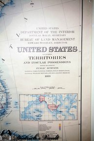
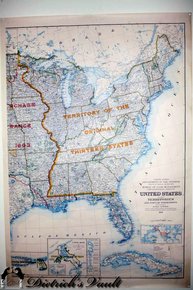
Bureau of Land Management Map. Multi. Paper. Department of the Interior, Bureau of Land Management, 1953 Map of the Eastern United States plus: Puerto Rico, Virgin Islands, Cuba, Panama Canal Zone and Panama. It shows the boundries and dates of lands acquired by purchase, annex, treaty and territories ceded. It also shows mountain ranges, rivers, National Parks, historic overland routes, reservations, lakes and other land managed by the department.
Antique Paper Items
Antique Maps
|